From Couch to Dog Mountain

Two and a half years ago, my lower back had gotten so bad that I couldn’t walk for more than a few minutes at a time without having to stop to sit or squat. Then came surgery, recovery, return of ability, and progression from there on. Yesterday I hiked up Dog Mountain. It was the most strenuous hike I’ve ever done. And as I sit here all sore the next day, I’m incredibly grateful to be able to do that.
Due to it’s incredible popularity, and limited parking, the Forest Service has been issuing permits for weekend days. Jenni bought ours a while ago, and we have been making small preparations ever since. Purchasing some gear (backpack, water reservoir, hiking poles), and going on light to moderate hikes starting in early Spring. Although we didn’t go on any hike for over a month before this, and that was a mistake.
We arrived at the trailhead just before 9:30am, met up with our friends, and started the hike a few minutes later. About half a mile up is a “difficulty fork” 😂

For the first 2.5 to 3 miles the trail is like many others in the Gorge, comprising of switchbacks through the woods.


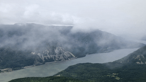
Halfway to the top the trail emerged from the forest briefly for a sweeping vista of the river and the gorge.

For the last half mile going up, we were out of the trees and surrounded by wildflowers. It was here that the wind also picked up significantly. This final stretch afforded gorgeous view all the way, with our trail surrounded by steep slopes full of wildflowers.


The views at the summit were incredible. Some fast moving clouds engulfed us soon after we arrived. That was quite a show before it cleared up in a few minutes. It was time to put on another layer. We sat there and enjoyed the views as we had lunch comprising of tasty sandwiches that Jenni had made, and some chips.


As we started back down, my IT band was hurting on the outer side of each of my knees. I was annoyed at myself for not having taken the time to go on hikes and do regular stretches since the Coyote Wall hike from over a month ago. Every downward step was painful. Soon Jenni reminded me of the cross-leg stretches and those helped. Those and the hiking poles were incredibly helpful in making the descent.


Heading back down we reentered the forest, and it sheltered us from the sun and wind for the rest of the way.

All in all this was a great hike with friends, and brought tremendous satisfaction on a personal level. It is entirely possible that someday my back may go bad again, but I’m grateful that I can do this today, and motivated to keep it this way. I’m also grateful for Jenni who has been supportive and encouraging all along the way ❤️
Activity stats:
Distance: 7 miles (11.27 km)
Elevation Gain: 2800 ft (853m)
Ascent/Descent: 800 ft/mile (75.76 m/km)
Time (including breaks): 5h 30m